

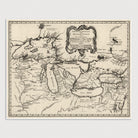
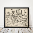
Great Lakes Antique Map Print (1755)
Archival print reproduction of an antique map of the Great Lakes from 1755 by Jacques Nicolas Bellin.
This map covers the area from Lake Superior in the northwest to western Quebec in the northeast, and from the Mississippi River in the southwest to Delaware Bay in the southeast. Shows a few towns, missions, forts, Indian villages and tribal territory, rivers and lakes, portages, and early place-names. Includes four legendary but non-existent islands in Lake Superior described by the Jesuit explorer Pierre de Charlevoix, thought to exist by explorers for many years.
Product Details
Medium: Archival pigment inkjet print
Paper: 100% cotton, museum-quality, acid-free, heavyweight, matte finish
Size: 11x14 or 16x20 inches (includes a 1/8 inch white border)
This print is sized to fit in a 11x14 or 16x20 inch frame without a mat, or a frame with mat opening sized for 11x14 or 16x20 inch art.
All prints come unframed.
Production Times & Shipping
We process and print all orders within 1–2 business days. Ground shipping is free within the US; ground shipping time is 1–5 business days. Shipping upgrades are also available. Read more about shipping.