


New Orleans, Louisiana USGS Topographic Map (1932)
Archival print reproduction of an antique map of New Orleans, Louisiana from 1932 by the US Geological Survey.
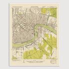
Historic USGS topographic map of New Orleans, Louisiana from 1932. The map covers the central portion of New Orleans, from the Mississippi River north to City Park, as well as the communities of Marrero, Harvey, and Gretna on the south side of the river. Shows numerous details, including roads, railroads, canals, ditches, marshes, and wooded areas. Also shows major buildings, including schools, churches, government buildings, and hospitals.
Product Details
Medium: Archival pigment inkjet print
Paper: 100% cotton, museum-quality, acid-free, heavyweight, matte finish
Size: 16x20 inches (includes a 1/8 inch white border)
This print is sized to fit in a 16x20 inch frame without a mat, or a frame with mat opening sized for 16x20 inch art.
All prints come unframed.
Production Times & Shipping
We process and print all orders within 1–2 business days. Ground shipping is free within the US; ground shipping time is 1–5 business days. Shipping upgrades are also available. Read more about shipping.