


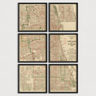
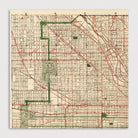
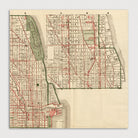
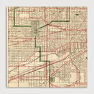
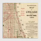
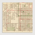
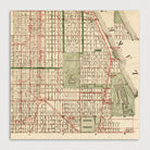
Chicago Antique Map Print Set (1906)
Archival print reproduction of an antique map of Chicago, Illinois from 1906 by Rufus Blanchard. Detailed early 20th century street map of the city covering an area north to Diversey Ave (with an inset in the upper right showing the area between Diversey and Lawrence Ave.), west to Pulaski Rd, and south to 71st St. All of the street car lines, elevated train lines, and railroads lines are shown with stations.
Product Details
Medium: Archival pigment inkjet print
Paper: 100% cotton, museum-quality, acid-free, heavyweight, matte finish
Size: 6 prints at 12x12 inches per print
Sold as a set of 6 individual prints. Each print is sized to fit perfectly in a 12x12 inch frame without a mat.
All prints come unframed.
Production Times & Shipping
We process and print all orders within 1–2 business days. Ground shipping is free within the US; ground shipping time is 1–5 business days. Shipping upgrades are also available. Read more about shipping.