
Paris Antique Map Print Set (1717)
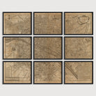
Archival print reproduction of an antique map of Paris, France from 1717 by Nicolas de Fer. The map is full of many details, including numerous buildings, churches, parks, labels for most streets, and the names of the surrounding faubourgs (or suburbs), all of which are now neighborhoods within the present-day city. A list of places of interest is shown in the lower left.
Product Details
Medium: Archival pigment inkjet print
Paper: 100% cotton, museum-quality, acid-free, heavyweight, matte finish
Size: 9 prints at 8x10, 11x14 or 16x20 inches per print
Sold as a set of 9 individual prints. Each print is sized to fit perfectly in a 8x10, 11x14 or 16x20 inch frame without a mat.
All prints come unframed.
Production Times & Shipping
We process and print all orders within 1–2 business days. Ground shipping is free within the US; ground shipping time is 1–5 business days. Shipping upgrades are also available. Read more about shipping.