


Rocky Mountain National Park, Colorado USGS Topographic Map (1919)
Archival print reproduction of an antique map of Rocky Mountain National Park from 1919 by the US Geological Survey.
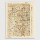
Historic USGS topographic map of Rocky Mountain National Park based on the 1940 reprint of the 1919 edition. The map covers all of Rocky Mountain National Park as well as the northern half of the Indian Peaks. Shows numerous details, including the locations of nearby towns, roads, mountains, lakes, ranger stations, some trails, as well as elevation contour lines. The park boundary is indicated in green.
Product Details
Medium: Archival pigment inkjet print
Paper: 100% cotton, museum-quality, acid-free, heavyweight, matte finish
Size: 16x20 inches (includes a 1/8 inch white border)
This print is sized to fit in a 16x20 inch frame without a mat, or a frame with mat opening sized for 16x20 inch art.
All prints come unframed.
Production Times & Shipping
We process and print all orders within 1–2 business days. Ground shipping is free within the US; ground shipping time is 1–5 business days. Shipping upgrades are also available. Read more about shipping.