

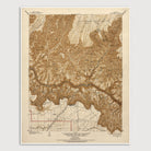
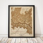
Grand Canyon, Arizona USGS Topographic Map (1903)
Archival print reproduction of an antique map of Grand Canyon National Park from 1903 by the US Geological Survey.
Historic USGS topographic map of the Grand Canyon based on the 1903 edition of the Bright Angel Quadrangle. The map covers the central area of Grand Canyon National Park, including Grand Canyon Village on the South Rim, and Bright Angel Ranger Station on the North Rim. Also shows numerous details, including roads, railroads, rivers and streams, trails, and elevation contour lines.
Product Details
Medium: Archival pigment inkjet print
Paper: 100% cotton, museum-quality, acid-free, heavyweight, matte finish
Size: 16x20 inches (includes a 1/8 inch white border)
This print is sized to fit in a 16x20 inch frame without a mat, or a frame with mat opening sized for 16x20 inch art.
All prints come unframed.
Production Times & Shipping
We process and print all orders within 1–2 business days. Ground shipping is free within the US; ground shipping time is 1–5 business days. Shipping upgrades are also available. Read more about shipping.