

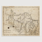
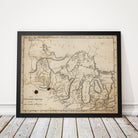
Great Lakes Antique Map Print (1816)
Archival print reproduction of an antique map of the Great Lakes from 1816 by Mathew Carey. Covers the western Great Lakes and includes Michigan, Wisconsin, and Minnesota.
Product Details
Medium: Archival pigment inkjet print
Paper: 100% cotton, museum-quality, acid-free, heavyweight, matte finish
Size: 8x10, 11x14 or 16x20 inches (includes a 1/8 inch white border)
This print is sized to fit in a 8x10, 11x14 or 16x20 inch frame without a mat, or a frame with mat opening sized for 8x10, 11x14 or 16x20 inch art.
All prints come unframed.
Production Times & Shipping
We process and print all orders within 1–2 business days. Ground shipping is free within the US; ground shipping time is 1–5 business days. Shipping upgrades are also available. Read more about shipping.