

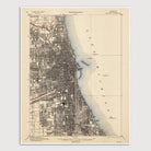

Chicago, Illinois USGS Topographic Map (1901)
Archival print reproduction of an antique map of Chicago, Illinois from 1901 by the US Geological Survey.
Historic USGS topographic map of Chicago based on the 1913 reprint of the 1901 edition. The map covers much of the city, from 79th Street in the south to Devon Avenue in the north, and westward to about Cicero Avenue. Shows numerous details, including streets (not labelled), railroads and parks, as well as elevation contour lines.
Product Details
Medium: Archival pigment inkjet print
Paper: 100% cotton, museum-quality, acid-free, heavyweight, matte finish
Size: 16x20 inches (includes a 1/8 inch white border)
This print is sized to fit in a 16x20 inch frame without a mat, or a frame with mat opening sized for 16x20 inch art.
All prints come unframed.
Production Times & Shipping
We process and print all orders within 1–2 business days. Ground shipping is free within the US; ground shipping time is 1–5 business days. Shipping upgrades are also available. Read more about shipping.