

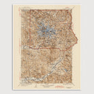
Mount Rainier National Park, Washington USGS Topographic Map (1928)
Archival print reproduction of an antique map of Mount Rainier National Park from 1928 by the US Geological Survey.
Historic USGS topographic map of Mount Rainier National Park based on the 1939 reprint of the 1928 edition, with additions in red made in 1944. The map covers all of Mount Rainier National Park as well as the area south of the park including the Cowlitz River valley south to the town of Randle. Shows numerous details, including roads, mountains, lakes, ranger stations, some trails, as well as elevation contour lines. The park boundary is indicated in red.
Product Details
Medium: Archival pigment inkjet print
Paper: 100% cotton, museum-quality, acid-free, heavyweight, matte finish
Size: 16x20 inches (includes a 1/8 inch white border)
This print is sized to fit in a 16x20 inch frame without a mat, or a frame with mat opening sized for 16x20 inch art.
All prints come unframed.
Production Times & Shipping
We process and print all orders within 1–2 business days. Ground shipping is free within the US; ground shipping time is 1–5 business days. Shipping upgrades are also available. Read more about shipping.