


San Francisco, California USGS Topographic Map (1899)
Archival print reproduction of an antique map of San Francisco, California from 1899 by the US Geological Survey.
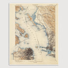
Historic USGS topographic map of San Francisco and the Bay Area based on the 1904 print of the 1899 edition. The map covers the northern half of the city of San Francisco, as well as Alameda, Oakland, Emeryville, Berkeley, Albany, El Cerrito, Richmond, and San Pablo in the East Bay, and most of the eastern coast of the Marin Peninsula from the Golden Gate north to San Rafael. Shows numerous details, including roads, railroads, buildings, rivers, marshes, named points and islands, as well as elevation contour lines. Shows the extent of the development in San Francisco at that time, with most of the buildings covering only the eastern portion of the city, and the area around Golden Gate Park labelled "Pueblo Lands of San Francisco".
Product Details
Medium: Archival pigment inkjet print
Paper: 100% cotton, museum-quality, acid-free, heavyweight, matte finish
Size: 16x20 inches (includes a 1/8 inch white border)
This print is sized to fit in a 16x20 inch frame without a mat, or a frame with mat opening sized for 16x20 inch art.
All prints come unframed.
Production Times & Shipping
We process and print all orders within 1–2 business days. Ground shipping is free within the US; ground shipping time is 1–5 business days. Shipping upgrades are also available. Read more about shipping.