

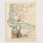
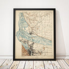
Portland, Oregon USGS Topographic Map (1897)
Archival print reproduction of an antique map of Portland, Oregon and Vancouver, Washington from 1897 by the US Geological Survey.
Historic USGS topographic map of Portland, Oregon and Vancouver, Washington based on the 1901 reprint of the 1897 edition. The map covers central and northern Portland, from approximately SE Division St. in the south, north to Salmon and Whipple Creeks in Washington, and includes all of present-day Vancouver. Shows the confluence of the Willamette and Columbia Rivers at a time before any bridges crossed the Columbia. Also shows numerous details, including streets (not labelled), buildings, railroads, streams, lakes, and elevation contour lines.
Product Details
Medium: Archival pigment inkjet print
Paper: 100% cotton, museum-quality, acid-free, heavyweight, matte finish
Size: 16x20 inches (includes a 1/8 inch white border)
This print is sized to fit in a 16x20 inch frame without a mat, or a frame with mat opening sized for 16x20 inch art.
All prints come unframed.
Production Times & Shipping
We process and print all orders within 1–2 business days. Ground shipping is free within the US; ground shipping time is 1–5 business days. Shipping upgrades are also available. Read more about shipping.