


Lewis and Clark Expedition Antique Map Print Set (1814)
Archival print reproduction of an antique map of the Lewis and Clark Expedition from 1814 by Samuel Lewis.
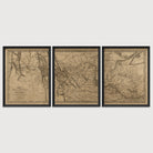
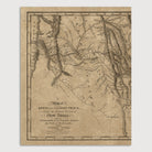
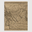
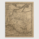
Prepared by William Clark and printed in 1814 by Samuel Lewis (no relation to Meriwether Lewis), this is the first detailed map of the American west and is based directly on the discoveries of the Lewis and Clark Expedition. The map covers the entire route of the expedition, from Saint Louis in the lower right to the Pacific Coast in the upper left (including the Missouri, Snake and Columbia Rivers), and contains a more detailed rendering of the Rocky Mountains than any previous map. The map includes annotations of the names, locations, and populations of numerous Native American tribes. The expedition's routes across the Rocky Mountains are also indicated.
Product Details
Medium: Archival pigment inkjet print
Paper: 100% cotton, museum-quality, acid-free, heavyweight, matte finish
Size: 3 prints at 11x14 or 16x20 inches per print
Sold as a set of 3 individual prints. Each print is sized to fit perfectly in a 11x14 or 16x20 inch frame without a mat.
All prints come unframed.
Production Times & Shipping
We process and print all orders within 1–2 business days. Ground shipping is free within the US; ground shipping time is 1–5 business days. Shipping upgrades are also available. Read more about shipping.