

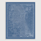

Chicago Vintage Map Art Print in Blue
Archival art print in a blueprint style based on an antique map of Chicago, Illinois from 1901 by George Franklin Cram. Covers an area from Diversey Ave. in the north to 68th St. in the south, and from the lake in the east to about Pulaski Rd. in the west.
Product Details
Medium: Archival pigment inkjet print
Paper: 100% cotton, museum-quality, acid-free, heavyweight, matte finish
Size: 11x14 or 16x20 inches (includes a 1/8 inch white border)
This print is sized to fit in a 11x14 or 16x20 inch frame without a mat, or a frame with mat opening sized for 11x14 or 16x20 inch art.
All prints come unframed.
Production Times & Shipping
We process and print all orders within 1–2 business days. Ground shipping is free within the US; ground shipping time is 1–5 business days. Shipping upgrades are also available. Read more about shipping.