

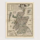
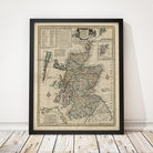
Scotland Antique Map Print (1752)
Archival print reproduction of an antique map of Scotland from 1752 by Emanuel Bowen. Includes numerous details, showing the names and locations of cities, towns, roads, bays, rivers, islands, and shires. An inset chart in the upper left lists the names of 30 shires and 15 Parliament boroughs, and an inset map at upper right shows the Shetland Islands.
Product Details
Medium: Archival pigment inkjet print
Paper: 100% cotton, museum-quality, acid-free, heavyweight, matte finish
Size: 11x14 or 16x20 inches (includes a 1/8 inch white border)
This print is sized to fit in a 11x14 or 16x20 inch frame without a mat, or a frame with mat opening sized for 11x14 or 16x20 inch art.
All prints come unframed.
Production Times & Shipping
We process and print all orders within 1–2 business days. Ground shipping is free within the US; ground shipping time is 1–5 business days. Shipping upgrades are also available. Read more about shipping.