
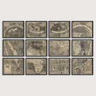
World Antique Map Print Set (1507)
Archival print reproduction of an antique map of the world from 1507 by Martin Waldseemuller.
Waldseemüller's 1507 map of the world is notable for containing the first appearance of the name America. The map is a tribute to the Ptolemaic tradition and the explorations of Amerigo Vespucci in 1501-02 down the eastern coast of South America. Waldseemüller places portraits of Ptolemy and Vespucci at the top of the map, adds the name "America" in South America.
The largest map of the world printed at the time, its depiction of the new world is notable for many geographical features: even though no European explorer is believed to have known of the existence of the Pacific Ocean, the western coast of South America is drawn with some degree of accuracy, and the Pacific Ocean is represented as a vast body of water separating the new world from Asia. Another mystery is that the peninsula of Florida seems to be represented on the map, even though the official discovery of Florida took place later, in 1513, by Ponce de León.
The original map was printed on 12 separate sheets.
Product Details
Medium: Archival pigment inkjet print
Paper: 100% cotton, museum-quality, acid-free, heavyweight, matte finish
Size: 12 prints at 8x10, 11x14 or 16x20 inches per print
Sold as a set of 12 individual prints. Each print is sized to fit perfectly in a 8x10, 11x14 or 16x20 inch frame without a mat.
All prints come unframed.
Production Times & Shipping
We process and print all orders within 1–2 business days. Ground shipping is free within the US; ground shipping time is 1–5 business days. Shipping upgrades are also available. Read more about shipping.