

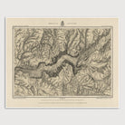
Yosemite National Park Antique Map Print (c1884)
Archival print reproduction of an antique map of Yosemite National Park, California from c1884 by George M. Wheeler.
Included in the final report of the Wheeler Expedition's Report of the Geographical Survey West of the 100th Meridian, this map covers all of Yosemite Valley. The map indicates trails and the names and elevations of various peaks in the area, as well as roads, place names, and structures within the valley itself.
Product Details
Medium: Archival pigment inkjet print
Paper: 100% cotton, museum-quality, acid-free, heavyweight, matte finish
Size: 16x20 inches (includes a 1/8 inch white border)
This print is sized to fit in a 16x20 inch frame without a mat, or a frame with mat opening sized for 16x20 inch art.
All prints come unframed.
Production Times & Shipping
We process and print all orders within 1–2 business days. Ground shipping is free within the US; ground shipping time is 1–5 business days. Shipping upgrades are also available. Read more about shipping.